Buying on the edge of a national park in Thailand
Thailand has 133 national parks and no statutory buffer zone. What the boundary rules out on the neighbouring plot, and how to check where it actually runs.
Thailand has 133 national parks and no statutory buffer zone. What the boundary rules out on the neighbouring plot, and how to check where it actually runs.
What exactly does a Thai national park protect?
In Thailand the word ‘park’ covers four distinct regimes, and confusing them is the most common mistake in the files we see. Three come under the Department of National Parks, Wildlife and Plant Conservation: the national park itself, the wildlife sanctuary and the non-hunting area, the last two founded on the wildlife conservation law. The fourth, the national reserved forest, comes under a different administration and a 1964 statute. Authority, applicable law, penalties and procedure differ in each case.
The parks regime changed in nature in 2019 — and it sits on top of, without replacing, the building rules we have set out province by province. The National Parks Act B.E. 2562, published in the Royal Gazette on 29 May 2019 and in force from 25 November that year, repealed the 1961 Act and raised the penalty for unlawful occupation or construction to a level out of all proportion to the old one. This tightening matters directly to anyone buying on the edge of a park, because it is not aimed only at the developer: it is aimed at whoever holds the land.
The Act offers a single route to regularisation for those who were already occupying land when the park took them in. Its section 64 required the department to survey, within 240 days of entry into force, the farmland and residential land lying inside areas declared before then. The permit issued on the strength of that survey is capped at twenty years. It is personal, temporary, and it cannot be sold. In other words, it is not a title, and it creates no transferable asset.
The four protection regimes, and what each changes for a neighbouring plot:
| Regime | Governing law | Administration | Units |
|---|---|---|---|
| National park | National Parks Act B.E. 2562 | Department of National Parks | 133 |
| Wildlife sanctuary | Wild Animal Conservation and Protection Act B.E. 2562 | Department of National Parks | 60 |
| Non-hunting area | Wild Animal Conservation and Protection Act B.E. 2562 | Department of National Parks | 75 |
| Forest park | National Parks Act B.E. 2562 | Department of National Parks | 119 |
| National reserved forest | National Reserved Forest Act B.E. 2507 | Royal Forest Department | n/a |
A word on the cost of use, which projections tend to leave out. The entrance-fee schedule in force since 7 June 2022 sorts the 133 parks into four categories and applies a one-to-five ratio between residents and foreign visitors: 200 baht against 40 at Khao Yai and Khao Sok, 100 against 20 at Khao Lak–Lam Ru, 500 against 100 in the Similans. Khao Yai’s two entrances, Noen Hom and Pak Chong, have charged foreigners double since September 2022. And the exemptions for the over-sixties and for people with disabilities are reserved for Thai nationals. For anyone settling twenty minutes from an entrance and walking there every week, this is no trifling detail.
A park boundary is a line, not a gradient
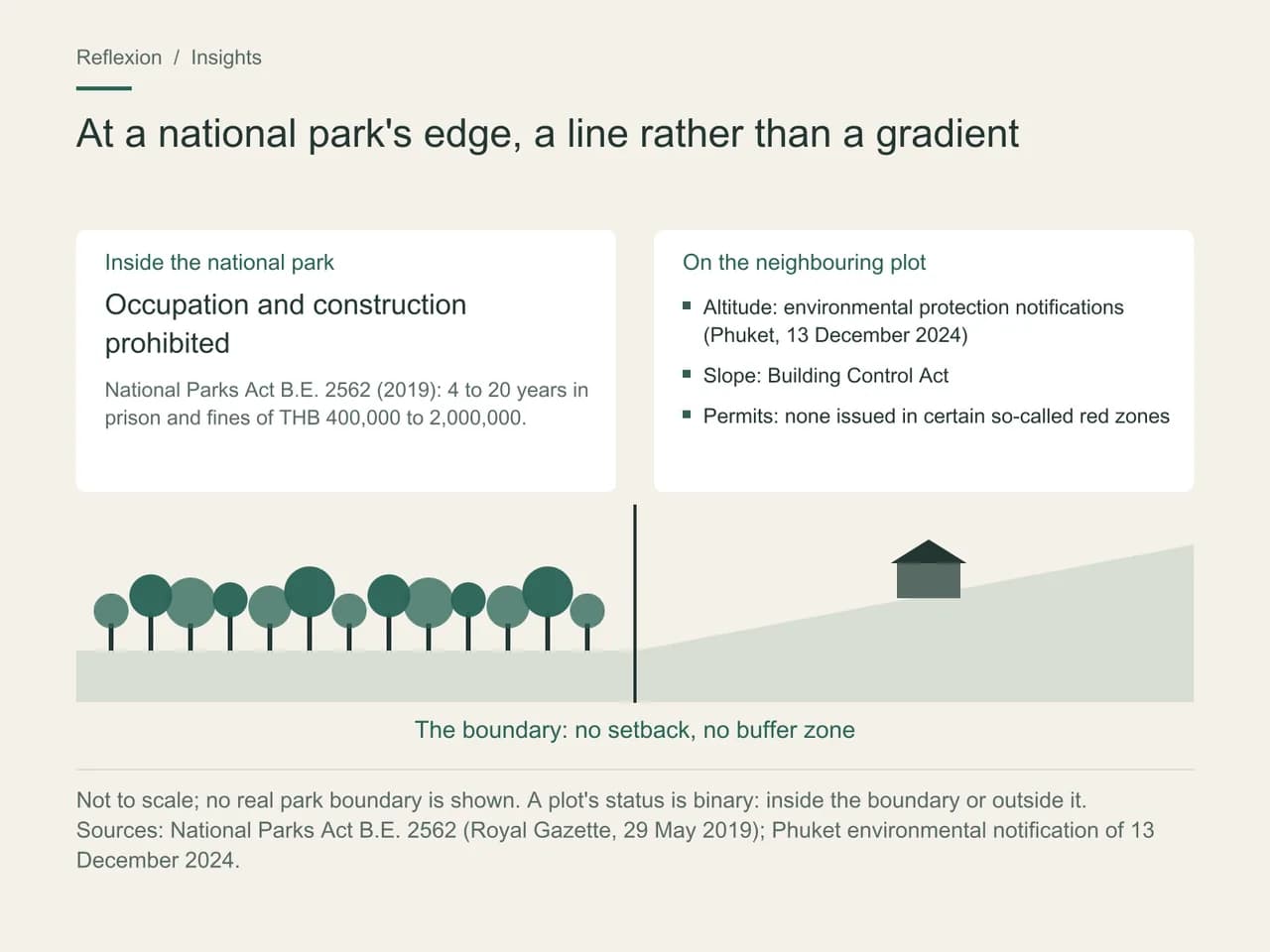
This is the point most brochures skate over, and everything else follows from it. The 2019 Act creates no buffer zone of any set width around a park. There is no statutory setback, no strip where building is merely restricted, no distance beyond which the risk fades away. A plot’s status is binary: it is inside the boundary, or it is outside. A figure of a three-kilometre buffer zone has been circulating in the press since February 2024; we do not adopt it, having been unable to find it in the text.
What actually puts numbers on building at the edge comes from other families of rules. In Phuket, it is an environmental protection notification published in the Royal Gazette on 13 December 2024: above 80 metres of altitude and up to 140, a single building no more than six metres high, a footprint of ninety square metres, seventy per cent of the plot left open and planted, and a title issued before 2017. On sloping land, it is the Building Control Act. In certain so-called red zones, no permit is issued at all. These rules sit on top of the park boundary without replacing it.
Which leaves the most practical difficulty of all: knowing which side of the line a plot lies on. The geometric reference data for park boundaries is not published. The national space agency’s portal displays layers with no established terms of use; the One Map portal can be reached only with a login; the polygons in the World Database on Protected Areas are indicative and carry no legal weight. The authoritative source remains the Royal Gazette, as a PDF, with no usable geometry. A buyer therefore cannot check alone what they are buying — and this is no theoretical difficulty, as what follows shows.
Thap Lan, or what happens when a boundary is redrawn
Thap Lan was gazetted on 23 December 1981 as the country’s fortieth national park: 1,397,375 rai spread across three provinces, the second largest in Thailand. Its boundaries were drawn forty-five years ago by aerial photo-interpretation, with no marking on the ground, and along the way they took in established villages and land-reform plots. A survey intended to correct the line was carried out in 2000; it was never finalised. Two waves of complaints reached the Ombudsman, in 2011 and again in 2018.
The administrative machinery started to move under the scheme known as One Map, run at a scale of one to four thousand. The Cabinet endorsed the 2000 line in March 2023, and the matter came before the National Park Committee in January 2024 — tabled for acknowledgement, not for deliberation. Then came the public consultation, from 28 June to 12 July 2024, on a proposal to take 265,286 rai out of the protected area, nearly a fifth of the park, and transfer it to the Agricultural Land Reform Office for residential and agricultural use.
The outcome of that consultation is one of the most telling figures in the whole affair: 947,107 respondents, of whom 901,892 were against and 45,215 in favour, or 95.2% opposed. The hashtag SaveThapLan carried the issue all the way to the Prime Minister.
The final decision came two years later, and it went almost unnoticed outside Thailand. On 15 June 2026, the National Park Committee approved the removal of 155,865.47 rai — not the 265,000 proposed. The remaining 109,420.99 rai stay inside the park pending case-by-case verification of rights, for which some five thousand two hundred people have registered under section 64. In return, 86,966.29 rai of reserved forest are to be brought into the park.
Then, on 25 June 2026, ten days later, the park banned the purchase, sale, exchange, transfer of rights and change of occupant on land within its boundaries, under section 20 of the 2019 Act, with a reminder that both buyers and sellers would be prosecuted. The stated reason was explicit: businesses and private individuals were trying to buy up residents’ rights.
The mechanism is worth remembering, because it runs against intuition. Redrawing a boundary does not open a market. It creates a personal right, limited in time, non-transferable, and locked against resale from the outset. The beneficiary is the verified long-standing occupant; the outside investor is expressly what the lock is aimed at.
One question remains open as we write. The Dong Phayayen–Khao Yai Forest Complex, which includes Thap Lan, has been on the World Heritage List since 2005, covering 615,500 hectares. The committee’s 2025 decision recalls that any revision affecting the property’s Outstanding Universal Value requires a significant boundary modification approved in advance. An updated report from Thailand is due by 1 December 2026. We will wait for that document rather than draw its conclusions for it.
Chanote or Nor Sor 3 Kor: why does a title read differently at a park’s edge?
Because the documented cases almost never turn on a mistake about location. They turn on the chain of title.
Thai land law ranks its documents, and that hierarchy reads more clearly at a park’s edge than anywhere else. The Chanote, with boundaries marked on the ground, is the strongest. The Nor Sor 3 Kor, surveyed by aerial photogrammetry without ground marking, leaves the holder open to boundary disputes. Below them, the Nor Sor 3, the Sor Kor 1 — no longer issued since 1972 — and the Por Bor Tor 5, a mere local tax receipt, carry no registrable real right, and on the tourist islands they frequently overlap parks, reserved forests or military zones, which rules out any conversion. We have set out elsewhere what each form of tenure actually allows.
The special case of the Sor Por Kor 4-01, land-reform land, is worth knowing even for those who will never buy it. It is reserved for landless Thai farmers and for agricultural use, and no arrangement allows a foreigner to hold it, lease it or profit from it. The land remains state property. A disguised sale is void, the state takes the plot back without compensation, and criminal exposure extends to every party. This is precisely the document that was issued, in January 2024, over a little more than seven rai inside Khao Yai National Park; in February, the Ministry of Agriculture agreed to revoke the certificates concerned and to stop allocations near national parks.
Not every high-profile demolition is a national park case.
The Koh Samui villas demolished or targeted since 2024 fall under the Building Control Act — slope, permits — and local environmental regulations. The Hat Nui demolition in Phuket, in July 2026, concerned national reserved forest and the 1964 Act, not a park. Only the Sirinat and Thap Lan cases are national park cases in the strict sense. Four regimes, four procedures: lumping them together is the easiest mistake to make, and the most expensive.
Fraud at the upstream end of the chain is the most instructive mechanism. In October 2017, the Central Criminal Court for Corruption Cases convicted three former officials over a Chanote issued for six rai at Layan, in Phuket, on the basis of a Sor Kor 1 attached to another plot. The irregular title had been resold for 330 million baht before it was revoked. And in July 2026, a final Supreme Court ruling cancelled title deeds and ordered the demolition of a hotel on more than thirteen rai at Sakhu, in Thalang district, for encroaching on Sirinat National Park — where 1,035 rai of encroachment had long been confirmed. Six Sirinat cases are following the same fast-track procedure; two have been finally decided, and enforcement is under way on more than twenty-five rai. At the end of July 2026, the government extended the procedure to the whole island.
The parks whose boundaries genuinely touch a residential market
Of the 133 parks, only a handful border a market where a foreign buyer is likely to be approached. Here they are, with what the edge means in each case.
| Park | Gazetted | Area | Neighbouring market |
|---|---|---|---|
| Khao Yai | 18 September 1962, the country’s first park | 2,166 km² | Pak Chong and Mu Si, Thanarat Road, about 200 km from Bangkok |
| Thap Lan | 23 December 1981 | 2,236 km² | Wang Nam Khiao, continuous with the Khao Yai corridor |
| Khao Sok | 22 December 1980 | 739 km² | Khlong Sok village, less than two kilometres from the entrance |
| Sirinat | 13 July 1981 | 90 km², of which 22 on land | Mai Khao, Nai Yang, Nai Thon, Layan, in north-west Phuket |
| Khao Lak–Lam Ru | 30 August 1991 | 125 km² | Khao Lak village, about ten kilometres away |
| Mu Ko Ang Thong | 12 November 1980 | 102 km², 42 islands | Seen from Koh Samui’s west coast, 28 to 30 km away |
Two readings. The first: Sirinat is the only park on this list that forms a direct enclave within a high-end residential market, and it is also the one carrying the heaviest litigation. That is no coincidence. The second: Mu Ko Ang Thong, which Koh Samui listings like to showcase, is an archipelago some thirty kilometres offshore, open only to licensed operators. It is a view, not a neighbour. The constraints that genuinely weigh on a Samui plot come from elsewhere. To place these markets against one another, we have compared Thailand’s six destinations, and treated Phuket in its own right in our reading of the island as a main home.
Park revenues give an idea of actual visitor numbers, in the absence of consolidated counts. In fiscal year 2025, the 133 parks took 2.2 billion baht in entrance and accommodation fees. Hat Noppharat Thara–Mu Ko Phi Phi alone accounts for 648.9 million of that, Khao Yai for 138.4 million, Khao Sok for 99.8 million, Mu Ko Ang Thong for 45.4 million. The spread shows where tourist pressure lies — and therefore where an edge is sold, and where it is lived in.
One last point of vocabulary, a recurring source of errors in listings: Khao Phra Thaeo, in Phuket, is not a national park. It is a non-hunting area, the most flexible of the department’s three regimes. Mistaking it for a park leads buyers to overestimate the protection, and with it how long the view will last.
When we model the case of Alison and Graham, on the edge of Khao Yai
Alison, 57, and Graham, 61, are looking for a house in the Pak Chong corridor, with a budget fixed at 18 million baht (€469,100). They are offered two plots. The first, on Thanarat Road, comes with an old Chanote and a finished house. The second, higher up, has a view of the massif, a price per square metre a third lower, and a Nor Sor 3 Kor.
What the available documentation allows us to tell them: the second plot is not necessarily open to challenge, but its status is not something they can verify. A photogrammetric survey without ground marking, on the edge of a park whose boundary exists only as a PDF, in an area where land-reform allocations were revoked in 2024 — each of these is unremarkable on its own, and together they describe precisely the situation in which the documented cases arose.
What we tell them to do: ask the provincial land office for the document’s full provenance, generation by generation, and have it read by a Thai lawyer. Commission a joint boundary survey from a licensed surveyor. And if the provenance goes back to a Sor Kor 1 or to a land-reform allocation, treat the one-third price gap as payment for a risk, not a bargain. We have no figure to put on that risk: no one has measured the park-edge premium or discount in Thailand. We have a procedure, and it is worth more than an invented number.
Modelled scenario. This profile is not a client; the parameters are working assumptions.
What our database allows us to put in context
We index developments across six provinces down to sub-district level, with their location and price per square metre. Overlaying that geography on the map of protected areas answers a question no brochure asks: does this land border a national park, a sanctuary, a non-hunting area or a reserved forest — and which side of the line is it on? The four answers do not come at the same price. To place a specific address, start by seeing it in its surroundings.
What you can do now
Three steps before signing anything on a park’s edge. Name the regime: ask the seller in writing which form of protection applies, and check the answer with the park office concerned, which does reply. Trace the chain of title back to its origin, not just to the previous owner — it is at the origin that cases are decided. And have the plot surveyed: a document drawn up by photogrammetry does not tell you where the line runs on the ground, and on the edge of a park that is the only thing that matters. None of these three steps appears in a listing, and all three together cost less than a week of litigation.
Frequently asked questions
Can you build on land that borders a national park?
Yes, provided the land lies outside the park and complies with the ordinary rules on height, slope and altitude. The parks legislation imposes no setback from the boundary. So the real issue is not how far you are from the park, but whether you can be sure you are on the right side of the line — something only a joint boundary survey can establish.
What are the risks if the plot turns out to be inside the park?
The 2019 Act provides for four to twenty years’ imprisonment, a fine of 400,000 to two million baht, an obligation to pay for restoration, and a daily fine for failing to carry out a demolition order. The land administration must formally revoke the title deeds before any demolition can be enforced.
Does the Thap Lan boundary revision open up a land market?
No. The land taken out of the park in June 2026 feeds a verification of rights for identified occupants, and from 25 June the park barred any transfer or change of occupant within its area, with buyers and sellers alike in its sights. What the exercise yields is a personal, temporary right that cannot be traded.
Can a foreigner hold land-reform land?
No arrangement makes it possible. The regime is reserved for landless Thai farmers, limited to agricultural use, and the land itself remains state property. An indirect acquisition is void as a matter of law: the plot reverts to the administration without compensation, and criminal liability can reach everyone involved.
Is there an official map of park boundaries?
Not in a reusable geometric form. The text published in the Royal Gazette is authoritative, but only as a PDF. The layers available elsewhere are indicative or sit behind a login. That gap explains how, in 2024, a government agency and a park could set two different maps against each other for the same plots.
Does being close to a national park raise a property’s value?
No one has measured it in Thailand. The research available deals with urban land or with visitors’ willingness to pay, not with the value of a park-edge plot. The market tells a story that research has not verified: we present it as such rather than put forward a percentage.
Method and sources
Sources checked October 1, 2026
Exchange rate used: 1 EUR = 38.374 THB (1 October 2026)
- What this article draws on: the Royal Thai Government Gazette for the two B.E. 2562 Acts of 29 May 2019 and for the Phuket environmental protection notification of 13 December 2024; the protected-area counts and the reading of sections 41, 64 and 65 set out in the IUCN case study on the adaptation of Thailand’s forest laws, 2021; Department of National Parks press releases and fee schedules for the entrance fees of 7 June 2022 and the revenue for fiscal year 2025; the leading Thai press for the Thap Lan timeline, the July 2024 consultation, the committee decision of 15 June 2026, the transfer ban of 25 June 2026, the Khao Yai land-reform certificates case and the Phuket court rulings; UNESCO’s property file no. 590 and decision 47 COM 7B.14 for World Heritage status. The penalties under section 41 are given in the version used by Thai sources, four to twenty years; one professional English-language source gives five to twenty. We reproduce no park boundary: this article describes regimes and procedures.
This article is general information, not legal or tax advice. The rules cited are dated: check with a qualified professional that they are still in force before acting.