Thailand's national spatial plan: cities and urban planning
Pattaya and Phitsanulok are joining Chiang Mai, Phuket and four other cities as regional centres: one of the decisions in the national spatial plan published in Thailand's Royal Gazette on 5 October 2026. The document sorts 325 cities and towns into five tiers by 2037, against 135 in its baseline, and attaches a level of facilities to each tier: hospitals, public transport, water, networks. Patong, Chalong and Hang Dong are named in it. For anyone choosing where to live in Thailand, it is the map of the places the state intends to equip.
Which cities does Thailand want to grow by 2037?
Eight cities will each anchor a region by 2037, according to the 2026–2037 National Spatial Policy Plan: Chiang Mai, Nonthaburi, Khon Kaen, Hat Yai, Nakhon Ratchasima and Phuket, which already hold that rank, joined by Pattaya and Phitsanulok. Prepared by the Department of Public Works and Town & Country Planning, or DPT, and published in the Royal Gazette on 5 October 2026, the plan places these centres directly below Bangkok, the only city of international rank (printed page 59). Pattaya's promotion, which we examine in the employment area behind the seaside city, is the most visible for a foreign buyer. Phitsanulok's gives the North a second centre after Chiang Mai.
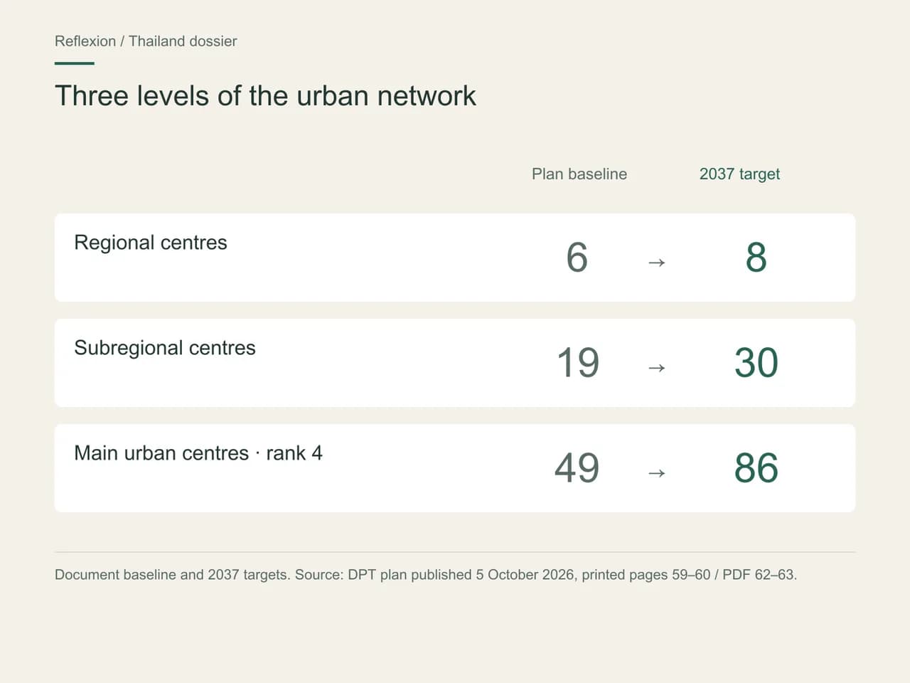
Below these eight centres, the whole pyramid widens. Subregional centres rise from 19 to 30: Chon Buri, Chachoengsao, Mae Sot and Rangsit join Koh Samui, Hua Hin and Krabi. The fourth tier, main cities (labelled “City” in the plan), grows from 49 to 86; the fifth, small towns (“Town”), from 60 to 200 (printed pages 59–60). Added together, the five tiers rank 325 cities and towns by 2037, against 135 in the baseline. This is the direct expression of one of the section's five policies: spreading prosperity to the regions and rebalancing the urban network.
A tier is not an honorific: the plan attaches a list of target facilities to each one (printed page 71). A regional centre is expected to bring together a specialist hospital accredited to international standards, universities and research centres, a digital network of at least 5G, an international convention centre, public transport within and between cities, and a regional park. At the fifth tier, the list becomes that of a well-served small town: a general hospital or large community hospital, vocational education, public transport, a neighbourhood park (printed page 72). A town's tier therefore sums up what the state intends to see there by 2037.
The ranking runs through the rest of the plan. Bangkok and the eight regional centres form exactly the list of nine cities targeted for expanded wastewater collection and treatment, and the list of nine sponge cities (printed page 77); they feature in the extension of drinking-water supply, alongside ten towns in the special economic zones, and they are the nine targets for development around stations, known as transit-oriented development or TOD (printed page 20). The energy chapter follows the same order for electric-vehicle charging points: tiers 1 and 2 up to 2027, tiers 3 and 4 from 2028 to 2032, tier 5 from 2033 to 2037 (printed pages 121–122). Tier sets the order of priority.
The plan also looks beyond municipal boundaries. It designates four conurbations to be managed as single units: Bangkok and its surrounding area, and the Eastern Economic Corridor, or EEC (Chachoengsao, Chon Buri, Rayong), at national level; Chiang Mai–Lamphun and Hat Yai–Songkhla at regional level (printed page 61). For each, it calls for a management committee and a master plan, due in 2027 for Bangkok and the EEC, 2032 for Hat Yai–Songkhla and 2037 for Chiang Mai–Lamphun (printed page 63). It acknowledges what every resident already knows: you live in one municipality, but you work, see a doctor and shop across a conurbation.
The ambition behind this map is set out at the start of the document: a country that is “a good place to live for all, connected to its region, driven by innovation and ready for sustainable growth” (printed page 8). It also comes with a number. The target is average growth in gross provincial product of 4% by 2032 and 5% by 2037 in the provinces hosting these centres, against 3.6% in the baseline (printed page 63). In other words, growth spread more evenly, bringing jobs and services closer to the places where people choose to live.
Jobs and services: where does year-round living make sense?
Year-round living is best judged where the plan aligns jobs, housing and urban tier, and the East is the clearest example. There the DPT targets quality housing for workers in Si Racha and Ban Chang districts, in the same table as the smart ports of Laem Chabang and Map Ta Phut and the smart airport at U-Tapao (printed page 73). Both towns are also promoted to the fourth tier. Housing, business and services move forward together here: it is the most useful lens for an address away from the tourist circuit.
The housing policy extends this principle to Bangkok, the regional centres and the subregional centres. It targets housing schemes close to jobs, schools and mass transit to cut commuting times, public housing near transport for low-income households and older people, the renewal of older neighbourhoods and more mixed-use districts (printed pages 74–75). For a buyer, being close to a future station also signals the kind of neighbourhood the plan wants new residents to move into.
Healthcare follows the same geography. Centres for complex treatment are targeted in Bangkok and the provinces of Chiang Mai, Phitsanulok, Khon Kaen, Nakhon Ratchasima, Nonthaburi, Chon Buri, Phuket and Songkhla — in other words, the provinces of the eight regional centres (printed page 94). Rehabilitation centres for patients and older people cover 26 areas, including Phuket, Chiang Mai, Chon Buri and Rayong. The document also counts 59 facilities in the country accredited by Joint Commission International (printed page 91). Our article on the services that shape an address connects these lists with water, schools and digital access.
For anyone working remotely, the digital chapter matters as much as the view. Fibre is to be upgraded in the EEC, the special economic zones, the four regional corridors and a set of provinces that includes Chiang Mai, Phuket and Prachuap Khiri Khan, then extended to the central district of every province (printed pages 172–174). In cities of the top three tiers, the target is a network of at least 5G (printed page 71).
Urban public transport completes the map. Seventeen cities are targeted for a mass-transit system, from Bangkok to Chiang Mai, Phuket, Pattaya, Khon Kaen, Hat Yai and Rayong (printed page 153). For a resident who wants to live without a car, it is one of the first lists to check. The table below sets out the top two levels of the hierarchy beneath Bangkok.
Two indicators of the urban system in the plan:
| Function | Plan baseline | 2037 target |
|---|---|---|
| Regional centres | 6 | 8 |
| Subregional centres | 19 | 30 |
How do you get from a national plan to an address?
First, by separating what the plan commits from what it leaves to local levels. Under section 12 of the Town Planning Act B.E. 2562 (2019), once the plan is published, government agencies must act in line with its directions, with advice from the DPT (printed page 6). It therefore steers public action and public investment. The permitted use of a plot, by contrast, is governed by provincial and municipal town plans and the corresponding permits.
The second habit is to read the timeline column. Every measure in the plan is tied to a horizon — short term 2027, medium term 2032, long term 2037 — and to the agencies responsible. The Chiang Mai–Lamphun master plan, due by 2037, does not run on the same clock as the EEC's, due by 2027. What separates a good project from an average one often comes down to this precision: a seller who invokes the plan should be able to say which measure, on what horizon, carried by which agency.
The third is to come down to the building. A province targeted for complex care does not tell a household how far it will be from the right hospital; a province targeted for fibre does not say which provider serves a given development. Those answers are checked on site: the actual journey to the hospital and the school, the internet service available in the building, the connection to the public sewer network.
Land works the same way. The plan caps the urban share of the country at 2.79% in 2027, 2.99% in 2032 and 3.24% in 2037, against 2.39% in 2021, while targeting 35% natural forest and at least 43.11% farmland in 2037 (printed page 50). Cities can grow, within a defined national envelope; exactly where that growth goes is for local plans to decide. Our article on Thailand's land and how it is used follows that question down to the plot.
Phuket and Chiang Mai: what does a regional perspective add?
A regional view takes each destination beyond its main town. In Phuket, the plan does not stop at Phuket City, a regional centre: Patong is promoted to the fourth tier, and Chalong, Rawai and Karon enter the fifth, alongside Kathu, already listed (printed pages 59–60). The communities of the south and west of the island, which buyers know for their beaches, thus join the state's urban grid, with the level of services that goes with it.
The island also sits within a region. The Andaman Wellness Corridor brings together Phuket, Krabi, Phang Nga, Ranong, Trang and Satun (printed page 183), and the plan selects these six provinces, together with those of the regional centres, for a “Health Trade Complex” combining care and medical training (printed page 94). Phuket is also already a UNESCO Creative City of Gastronomy (printed page 216). For a couple who winter on the island and are thinking of living there all year, these lists sketch a living area much wider than the coast.
Around Chiang Mai, the same logic applies. Mae Rim, Hang Dong, Suthep and Mae Hia are promoted to the fifth tier (printed page 60). The Chiang Mai–Lamphun conurbation is given a mass-transit project linking the two cities and a master plan for a “Lanna creative economy city” (printed page 74). The Northern Economic Corridor, or NEC, groups Chiang Rai, Chiang Mai, Lamphun and Lampang around the creative economy (printed page 183); Chiang Mai is already a UNESCO Creative City for crafts and folk art (printed page 216).
The two destinations also share an airport project. The plan's programme provides for a second airport for Chiang Mai, between Ban Thi (Lamphun) and San Kamphaeng (Chiang Mai), and a second for Phuket, in Phang Nga, because the existing airports are over capacity (printed page 153); the tourism section calls them the Lanna and Andaman international airports (printed page 139). Neither a timetable nor site boundaries have been fixed: our article on the Lanna and Andaman airports follows their progress and what it means for the areas around them.
Helen and David, between Phuket and Chiang Mai
Helen and David, both in their sixties, have spent their winters in Phuket for several years and are thinking of settling there for good. David is being treated for a heart condition; Helen wants to be able to live without a car. They are torn between the south of the island and the outskirts of Chiang Mai, where friends of theirs live. The couple are fictional, created to show how the plan can help settle a choice.
They start with the plan. On both sides, the main city is a regional centre and the province is among those targeted for complex care; Chalong and Rawai, like Hang Dong and Mae Rim, enter the fifth tier. Phuket and Chiang Mai are both among the seventeen cities targeted for mass transit, but the Chiang Mai–Lamphun conurbation plan is not due until 2037. For a couple without a car, what counts is the transport that exists today.
Their decision is made: they focus their search on Chalong and Rawai, where David's cardiologist already practises, and set aside ten days in March to time, from each shortlisted development, the actual journey to the hospital and to the nearest public-transport stop. Chiang Mai becomes their second option, to be looked at again once the conurbation plan is published.
Modelled scenario. This profile is not a client; the parameters are working assumptions.
Which questions should you ask before choosing a property?
Four questions are enough to connect a property with the plan. Which municipality is it in, and which tier does the plan give it? Does that municipality appear on the lists that matter to you: water, sanitation, mass transit, healthcare, fibre? On what horizon are the measures concerning it scheduled? And what does the local town plan say about the plot? The first three answers are in the national document; the fourth lies with the provincial or municipal planning office.
The physical conditions of the site complete the picture. The plan counts 370 cities and communities in 100-year flood zones, 214 exposed to landslides when rainfall exceeds 100 mm a day and 844 in earthquake zones; it aims to discourage building on slopes steeper than 35 degrees and in repeatedly flooded lowlands (printed pages 64–65). These national counts tell you where to look; the history of the land and of the building tells you what is actually there.
What you can do now
Write down the exact municipality of every property you look at — Chalong rather than Phuket, Si Racha rather than the EEC — and look it up in the lists on printed pages 59 and 60 of the plan. Within minutes you will know which tier the state gives it and which facilities it intends to provide there by 2037. That is the first line of a comparison that continues on the ground, address by address.
Each article in the “Thailand 2037” series applies this reading to one territory, and our catalogue of map guides carries it onto the map.
Frequently asked questions
Why does Thailand's national spatial plan matter to a property buyer?
Because it shows where the Thai state will concentrate public facilities until 2037. Every city and town is given a tier, from Bangkok down to the 200 small towns of the fifth level, and that tier recurs in the lists for hospitals, transport, water and fibre. A buyer can read in it the order of priority for public action around a property; the plot itself falls under local town plans.
What does Pattaya's promotion to regional centre mean?
Pattaya moves up to the second tier of Thailand's urban hierarchy, with only Bangkok above it. By 2037 that status calls for regional-level functions: an accredited specialist health facility, universities, a convention centre, urban and intercity public transport. Pattaya is also one of the nine cities targeted for wastewater treatment and sponge-city works. These are targets published in October 2026, to be followed measure by measure.
Are Patong, Chalong and Rawai named in the plan?
Yes, by name. Patong is one of the 37 towns promoted to the fourth tier, that of main cities; Chalong, Rawai and Karon are among the 140 communities promoted to the fifth, where Kathu already sits. This ranking, published on printed pages 59 and 60, ties these Phuket localities to a target level of services: hospital, vocational training, public transport and a park.
Have the second airports for Phuket and Chiang Mai been confirmed?
They are written into the plan as development areas, with no published timetable or site boundaries. The document justifies them by congestion at the existing airports and locates them in Phang Nga for Phuket and between Ban Thi and San Kamphaeng for Chiang Mai. Their progress can be tracked through each project's own administrative stages, which our article on the Lanna and Andaman airports sets out.
Does the national plan make land buildable?
No. Since publication it binds government agencies, which must act in line with its directions, but it does not set the use of any plot. Whether land can be built on depends on provincial or municipal town plans and local permits. What the plan does provide is the national frame: it caps urban land at 3.24% of the country in 2037, against 2.39% in 2021.
Method and sources
Sources checked October 12, 2026
Exchange rate used: 1 EUR = 38.374 THB (28 September 2026)
- What this article relies on: a single primary source, checked on 12 October 2026. It is the plan ผังนโยบายระดับประเทศ (พ.ศ. 2569–2580), published by the Department of Public Works and Town & Country Planning (DPT), Thailand's Ministry of Interior, and rendered here as “National Spatial Policy Plan 2026–2037”. The notice was signed on 16 September 2026 and published in the Royal Gazette on 5 October 2026 (volume 143, special issue 242 ง, page 20), its identity checked against the first page of the PDF. The plan sets out directions and targets; facilities, funding and services at a given address require sources of their own.
- DPT, national plan 2026–2037, 5 October 2026. References use printed page numbers; in the body of the document, the PDF page number is the printed number plus three. Passages used: printed pages 6, 8, 20, 50, 59–65, 71–77, 91, 94, 121–122, 139, 153, 172–174, 183 and 216. Buddhist Era years are converted to Gregorian years by subtracting 543.
- The translation is selective and editorial. We distinguish the plan's content, its 2037 targets and our residential analysis method. The total of 325 cities and towns (135 in the baseline) is the sum, calculated by Reflexion, of the five tiers published on printed pages 59–60. The couple in the scenario are fictional. No market, price or return figure is derived from the document's directions.
This article is general information, not legal or tax advice. The rules cited are dated: check with a qualified professional that they are still in force before acting.